Vehicle v pole tool
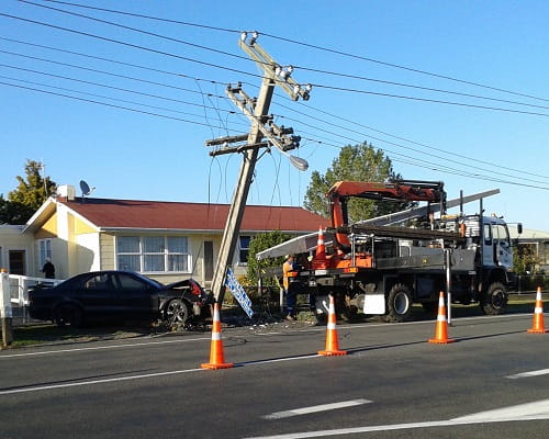
The electricity industry and emergency services regularly respond to vehicle versus power pole incidents. While they inevitably lead to power outages for our customers – either as a direct result of the incident or to allow for repairs - there’s a large personal cost to those who are harmed, their friends and families, and people who have to attend these incidents.
Rather than letting the trend continue, we’ve been working on ways that we can help reduce the instances of vehicles colliding with power poles.
This work has led to us developing an ArcGIS tool to identify high risk power poles and crash sites on our electricity network. The data captured will help us plan our future overhead assets and improve public safety through design.
How it works
Designed by geospatial company Orbica, in conjunction with our overhead assets and GIS teams, the tool can quickly pinpoint any public road on Powerco’s electricity network footprint to identify where the crash hotspots are, and how and if they correlate with our roadside assets.
Using a combination of Waka Kotahi crash data from 1980 to now, layered with Powerco’s power pole location data, the tool identifies:
- All crashes, including date and time, which direction the vehicle was heading, and GPS of the final position of the vehicle
- Crash severity – whether it was a fatal, serious, minor and non-injury crash
- Weather conditions at the time of the crash
- The road’s speed limit, usual traffic flow and typography, eg whether it’s curved, inclined or straight
- Whether an object was struck and what it was, eg a power pole
“It helps us identify high risk poles and crash sites, so we can design our overhead rebuilds for safer roads. I truly believe it will help save lives,” says Powerco Asset Fleet Manager, Overhead Assets and Investment Delivery, Ken Pattie.
“Being able to identify the overall road risk, not only where high-risk poles are, is important. If we move the pole, we don’t want to move it to another spot where there’s more risk of a vehicle versus pole.”
Industry leading
Ken describes the work Powerco is doing to help stop car v pole incidents as “ground-breaking”. After presenting the tool at an Electrical Engineers’ Association (EEA) Public Safety Working Group learning event with Connectics in mid-2021, Ken received enquiries from four other lines companies wanting more information.
Our overhead engineers are already using the tool as part of overhead renewal project planning. If a accident hotspot is found, the pole can be moved to a “safer” spot as part of the project.
“We’ve found that most of our roads are low risk, but there are some real hot spots. It’s those hot spots that we will target first,” says Ken.
Case study – Waka Kotahi safety upgrade, State Highway 3, New Plymouth to Egmont Village
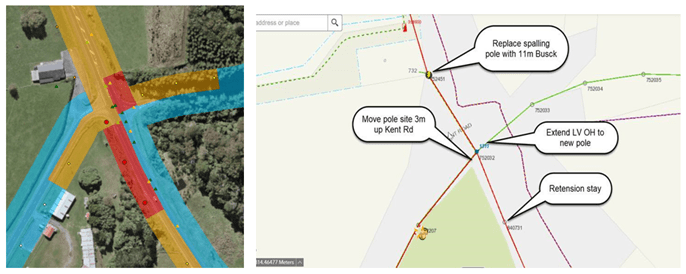
New Zealand Road Transport Agency Waka Kotahi is redesigning a high-risk section of SH3 (Junction Road) between New Plymouth and Egmont Village. Using the ArcGIS tool, our team worked with the agency to ascertain whether our power poles along the route were in appropriate locations, so they supported public safety, rather than risk crashes.
To assist, we’re upgrading and redesigning the conductors to move our power poles out of the areas identified as high risk by the tool.
Below: SH3 between Egmont Village and Mangorei Rd, past Lake Mangamahoe in North Taranaki, as seen using the tool.
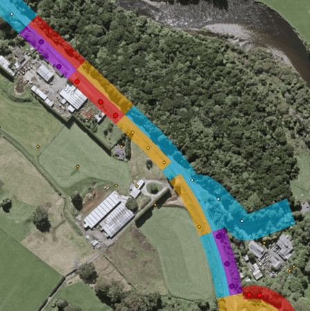
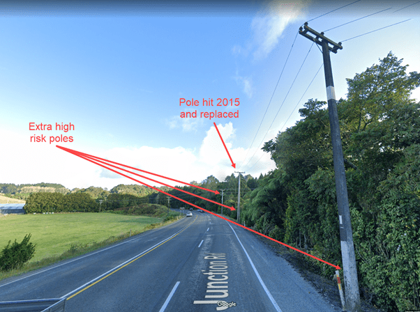
Above: The current route. Below: The new route removing the extra high risk poles.